Maps and Travel Information

When traveling to and within Yellowstone National Park you will come across some of the most beautiful scenes in the world. Be cautious when driving in the park, and stay alert for other visitors, wildlife and rapidly changing weather conditions.

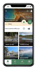
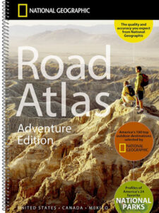
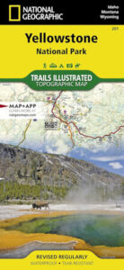
Internet can be spotty at best in the park! The best way to travel is with a large-scale map. Purchase a map from Yellowstone Forever’s online store and your purchase will help support the park!

Buy a Map

Yellowstone Travel Map


Yellowstone National Park Map

Winter Travel Information

Getting to the Lamar Buffalo Ranch Field Campus in winter:
In winter, the only accessible route to the Lamar Buffalo Ranch is via the north entrance to the park at Gardiner, Montana. From the north entrance, proceed south to Mammoth and then east via the all-season road connecting Mammoth and Cooke City. All other routes are closed to automobile traffic from November to April.

Within the park, the only services accessible to the Buffalo Ranch are in Mammoth Hot Springs, 29 miles to the west. In Mammoth, a National Park Service campground is operated year-round on a first-come, first-served basis; and a limited supply of groceries is available year-round at the Yellowstone General Store in Mammoth Hot Springs. As part of the ongoing improvements to park facilities, the Mammoth Hotel will be closed for the next two winters.

Additional services are available in the gateway communities of Gardiner, Montana, (34 miles west) and Silver Gate/Cooke City, Montana, (23 miles east). Gardiner is a larger town, with year-round motels, restaurants, gas stations, a laundromat, and a grocery store. Silver Gate and Cooke City are somewhat smaller and more seasonal, with motels, restaurants, gas stations, and convenience stores.